Cycling infrastructure
The position of cyclists has already been discussed, as well as types of crossings in the traffic rules for cyclists. There are also different types of cycling infrastructure.
Cycle path
Cycle paths are separated from the roadway for motorised traffic and are almost always red, either in asphalt or bricks. A blue sign with a bicycle on it indicates a mandatory cycle path. When riding your bike it is mandatory to use the cycle path when it’s there. The end of a cycle path is indicated with the same blue sign with a red line through it, this means cyclists have to use the roadway from this point on. A two way cycle path is indicated with a undersign below the blue sign, as well as markings in the middle of the cycle path.
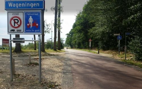
Bicycle street
A bicycle street is similarly designed as a bicycle path, however, with the exception that cars are allowed to entry the street as guests. Bicycle streets are clearly indicated, red asfalt and the traffic sign ''Fietsstraat - Auto te gast'', and designed for cyclists. In this way, it immediately makes clear that motorists are guests and need to behave accordingly. The maximum speed limit for all road users is 30km an hour. Cars and motorcycles need to provide space for cyclist and adapt their pace. Therefore, bicycle streets are very comfy places for cyclist to cycle on.
Moped/cycle path
These types of paths are usually found outside the urban area. On these paths cyclists share the cycle path with mopeds, as indicated with.
Recreational cycle network
In the Netherlands and Belgium a network of cycle routes connected via nodes (intersections of cycle paths) is available. The nodes are all numbered and are easily identified. With the help of a map of the cycle route network, you can compose your own bicycle tour by planning a route from node to node. Allowing you to make your own cycle route out of already existing long-distance cycle routes or loop-shaped cycle routes.